Category: Social Sciences, Maps, United Kingdom
Results
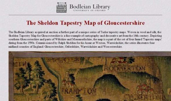
The Sheldon Tapestry Map of Gloucestershire The Bodleian Library acquired at auction a further part of a unique series of Tudor tapestry maps. Woven in wool and silk, the Sheldon Tapestry Map for Gloucestershire is a fine example of cartography and decorative art from the 16th century. Depicting southern Gloucestershire and parts of Wiltshire and Monmouthshire, the map is a part of the set of four famed 'Tapestry maps' dating from the 1590s. Commissioned by Ralph Sheldon for his home at Weston, Warwickshire, the series illustrates four midland counties of England: Gloucestershire, Oxfordshire, Warwickshire and Worcestershire.

Mapmaking and printing from 1820 to 2002
The Bartholomew Archive is the remarkable record of the Edinburgh-based firm of map engravers, printers and publishers, John Bartholomew & Son Ltd. It is one of the most extensive cartographic archives available for research in a public institution.
Members of the Bartholomew family were engaged in map-making from the first known map engraving work of George Bartholomew in 1825. John Bartholomew junior started printing operations before 1870. For more than a century afterwards the Bartholomew firm specialised in high-quality map production.
Importance of the archive
The Bartholomew Archive enables us to: